Iranian Satellite ‘Khayyam’ Introduces 80 Cutting-Edge Applications across Varied Industries
TEHRAN (Tasnim) – Iran's Khayyam satellite, launching a new era, introduces an array of 80 groundbreaking applications spanning environment, agriculture, urban planning, and beyond.
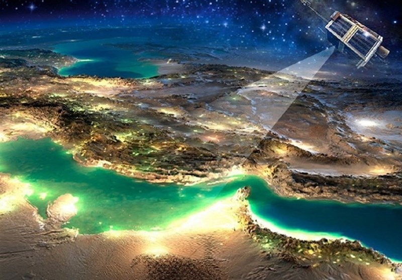
The many applications of Khayyam's remote sensing data, which serves a variety of industries including mining exploration, environmental analysis, agricultural optimization, water resource management, and disaster monitoring, are explored in this extensive report.
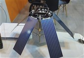
June 8, 2022, marked the launch date of Iran's Khayyam satellite from Kazakhstan's Baikonur Cosmodrome. Five years of critical data and imagery covering agriculture, environment, water resources, mining, border surveillance, and unexpected event management are anticipated from the 600kilogram, 500kilometer orbiting satellite.
Operated by Iranian experts stationed at communication technology bases, Khayyam's control commands have been active from the moment of launch. In a recent development at the Iranian Space Research Institute, Khayyam's images are poised for competitive commercialization and market expansion, now accessible through the institute's website.
Khayyam's applications range from environmental monitoring, agricultural precision, urban studies, and mining exploration to water resource surveillance and natural disaster management.
The satellite's environmental applications include observing Earth's surface changes, industry and mine dispersion monitoring, city and population area studies, and assessing pollutant movements in air, water, and soil. It also tracks land degradation, vegetation alterations, dust storm identification, and water body monitoring.
Within agriculture, Khayyam optimizes water consumption, monitors land use changes, and aids precision farming by analyzing planting periods, detecting plant diseases, and assessing soil conditions.
Urban planning benefits from Khayyam's data by mapping development projects, estimating populations, tracking urban land use changes, and identifying unauthorized constructions.
In mining, the satellite oversees site activities, produces topographic maps, monitors environmental encroachments, and aids in mineral volume estimation and transportation routes.
Water resource monitoring involves mapping rivers, wetlands, and water bodies, assessing flood vulnerabilities, and managing water resources effectively.
For natural disaster monitoring, Khayyam contributes to risk modeling, damage assessment, infrastructure monitoring, and early warning systems.
Khayyam's versatile applications across these sectors mark a significant leap in Iran's technological advancements, promising manifold benefits in various realms of economic and societal development.
The following are some of the ways Khayyam's satellite data is used in environmental applications:
- Monitoring and examining periodic changes in the Earth's surface.
- Monitoring and investigating the dispersion of industries and mines.
- Monitoring and studying the dispersion of cities and population areas.
- Observing the movement trends and displacement of pollutants in water, air, and soil.
- Assessing land degradation and desertification, monitoring soil erosion rates, and the status of deserts and arid lands.
- Studying changes in vegetation cover and forests.
- Identifying dust and sandstorm centers.
- Continuous monitoring of the country's water areas.
- Monitoring the status of environmental factors in the atmosphere, such as air pollution in cities.
- Monitoring the status of environmental factors in soil areas, such as organic materials.
- Monitoring the status of environmental factors in aquatic areas, such as oil spills on the sea.
- Identifying fires and estimating the resulting damages.
The Use of Satellite Data in Agriculture:
Water Resources:
- Optimizing water consumption management in agricultural fields.
- Assisting in determining water rights and allocating water resources to farms.
- Calculating evapotranspiration (ET).
- Studying soil moisture and plant conditions.
Lands:
- Monitoring land use changes.
- Monitoring changes in the area and types of cultivated crops.
- Generating maps of agricultural land cover.
- Monitoring the extent and area of cultivation in different regions.
Precision Agriculture:
- Optimizing water consumption management on farms.
- Assisting in optimizing harvest stages.
- Aiding in reducing waste during the production process.
Meteorology:
- Providing meteorological information to farmers.
- Examining the effects of climate change on the agricultural sector.
Cultivation:
- Monitoring crop planting periods.
- Identifying and investigating plant diseases.
- Estimating crop yields before harvest.
- Determining the type and quantity of required fertilizers.
- Identifying cultivated species.
- Determining soil types in different areas.
- Assisting in optimal farm management.
- Assessing the health of agricultural products.
- Detecting pests.
- Monitoring periodic changes in plant growth.
Market and Insurance:
- Providing market information on agricultural products to farmers.
- Providing accurate information to agricultural insurance.
- Determining damages to agricultural lands following natural disasters, pests, etc.
The Application of Satellite Data in Urban Studies and Planning:
- Generating maps for urban development projects.
- Analyzing urban population data.
- Estimating population figures.
- Real-time updating of city maps.
- Examining changes in urban land use.
- Identifying unauthorized developments.
- Infrastructure and transportation analysis.
- Assessing urban population distribution.
- Studying urban structural formations.
- Location planning for urban facilities and services.
- Informal settlements and marginalization.
The Use of Satellite Data in Mining Explorations:
- Monitoring mining site equipment and layout.
- Producing topographic maps.
- Overseeing contractor activities in mining operations.
- Monitoring and preventing encroachment on mining property or environmental surroundings.
- Supervising project progress and controlling mining operations.
- Overseeing different sections of mining sites such as extraction workshops, waste dump sites, conveyor belts, roads, etc.
- Creating fault and fracture line maps.
- Assisting in preliminary mining exploration and development studies.
- Analyzing soil composition changes.
- Identifying mining-related pollutants.
- Estimating the volume of minerals for loading and transportation.
- Analyzing mining road networks and determining optimal transportation routes.
The Application of Satellite Data in Water Resource Monitoring:
- Identifying riverbeds and their seasonal fluctuations.
- Mapping wetlands.
- Locating water bodies (lakes, rivers, etc.).
- Studying watersheds (for issues like flooding and waterlogging).
- Assessing vulnerability in cases like floods and waterlogging.
- Identifying the locations of rivers, aquifers, wells, and canals in urban areas.
- Planning methods for guiding surface water and preventing floods.
- Monitoring coastline changes.
- Identifying unauthorized constructions in riverbeds and encroachments on river margins.
- Managing water resources and examining the status of rivers, lakes, reservoirs, dams, etc.
The Use of Satellite Data in Natural Disaster Monitoring:
- Risk modeling and hazard map preparation.
- Vulnerability analysis.
- Monitoring affected areas.
- Spatial planning.
- Damage assessment.
- Identifying resettlement areas.
- Early warnings.
- Monitoring impacted infrastructure.
- Search and rescue route mapping.
- Mapping affected areas.